

Europe’s capacity to act in a changing world increasingly depends on timely, reliable information. Whether it’s monitoring ice melt in the Arctic, tracking forest fires in Southern Europe, or understanding urban expansion across the continent, Earth Observation (EO) provides the evidence base for decision-making. But the challenge is not only launching satellites—it is orchestrating them efficiently.
For decades, users requesting data have faced the same bottleneck: coverage takes time. A single mission can require weeks to complete imaging of a large country, let alone an entire continent. Meanwhile, fragmented requests and siloed ground-segment systems mean that valuable resources often remain underused, or worse, wasted.
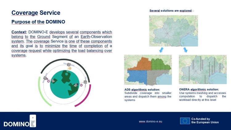
Domino-E’s Coverage Service Domino is designed to change this picture. Instead of treating missions as isolated assets, it builds on existing inventories and coordinates them globally—delivering fresher, faster, and more usable data.
Beyond Single Missions: Why Federation is Needed
Traditionally, users requesting EO data must rely on one satellite system at a time. That might be sufficient for small areas or long-term monitoring, but it is inefficient when the need is urgent. As Cédric Pralet from ONERA explains:
“Typically, in Earth observation, the mission center receives a set of requests from users wanting to observe different parts of the Earth. The challenge is that it’s not always possible to fulfill all requests due to resource limitations. The mission center must select which requests to prioritize while ensuring that the satellites have sufficient capacity to handle the selected tasks.”
(Cédric Pralet, Domino-E interview)
The Coverage Service addresses this by adding a federation layer on top of existing systems. Instead of asking the user to decide which constellation or provider should fulfill their request, the federation automatically distributes the workload across multiple missions.
“DOMINO-E introduces a federation layer that changes how requests are handled. Typically, users have to choose a specific system or satellite constellation to fulfill their requests. In DOMINO-E, users submit their requests to this federation layer, which then automatically dispatches them to the most suitable missions. This means users don’t need to worry about which system will handle their observation—it just gets done in the most efficient way possible.”
(Cédric Pralet, Domino-E interview)
This shift is not about replacing existing inventories. Instead, Domino-E builds on them, making them more effective by pooling global resources to deliver fresher images. For Europe, this ensures that data can be turned into action more quickly—whether for climate, security, or economic priorities.
From Algorithms to Action: Coordinating the Skies
The complexity of coordinating multiple satellites is staggering. Each mission comes with constraints—memory, energy, pointing capabilities, and weather limitations. Each request adds further variables. The result is billions of possible combinations. As Pralet describes:
“One of the major challenges is the sheer number of possible decisions we have to evaluate. For example, if a task requires 60 images and there are two systems available, you end up with billions of billions of possible combinations. Our job is to find an efficient algorithm that can quickly sort through these possibilities and identify a good solution.”
(Cédric Pralet, Domino-E interview)
This is where AI and optimization techniques enter the picture. Gauthier Picard, also from ONERA, frames the challenge in simple terms:
“Imagine you want to take pictures of different parts of the Earth using satellites. The challenge is figuring out which satellite should take each picture and when it should do it. There are many satellites moving around the Earth, and they can point their cameras in different directions. The goal is to make sure that the satellites work together in the best way possible to take all the pictures as quickly as they can.”
(Gauthier Picard, Domino-E interview)
The Coverage Service Domino applies algorithms similar to those used in optimization problems like the traveling salesman: find the shortest, most efficient path that still visits all required points. By distributing tasks across satellites, it reduces duplication, accelerates coverage, and ensures higher-quality results.
Timeliness as a Competitive Advantage
In Earth Observation, time equals value. Long-term monitoring requires regular revisits, but crises such as earthquakes, floods, or forest fires demand data within hours or days. As Picard notes:
“Most of the time, you need to acquire images of large areas, often for long-term observations. For example, if you’re monitoring the polar regions to track ice surface reduction, you need to capture the area repeatedly over an extended period to analyze changes. In contrast, during an emergency like an earthquake, the focus shifts to quick access to data about the disaster’s impact.”
(Gauthier Picard, Domino-E interview)
In such scenarios, the federation layer is more than a technical tool—it becomes a sovereignty enabler. By coordinating European and global missions, Europe can react at the speed of events, without waiting for external providers or risking gaps in coverage.
This approach aligns closely with EU policy priorities. The EU Green Deal and Digital Decade 2030 both depend on accurate, timely data for monitoring emissions, biodiversity, and land use. Likewise, the EU Civil Protection Mechanism requires rapid situational awareness during natural disasters. By reducing the time needed to generate coverage, Domino-E strengthens Europe’s competitiveness not just technically, but politically.
Looking Ahead: Beyond Optical
While current focus is on optical satellites, the Coverage Service framework is designed to adapt. As Picard highlights, future needs may involve integrating radar or infrared sensors, enabling imaging under cloud cover or at night.
“Currently, we focus on optical sensors, but other sensor types, like radar or infrared, could be used when weather or light conditions make optical imaging difficult. Our framework can adapt to these different scenarios, allowing for things like radar-based imaging when clouds are present.”
(Gauthier Picard, Domino-E interview)
This adaptability ensures that Europe is not locked into one technology or one provider. It is about building a resilient, flexible ecosystem—one that can scale as EO needs evolve.
Conclusion: A New Standard for European EO
The Coverage Service Domino does not replace Europe’s EO assets—it makes them more powerful by coordinating them intelligently. By layering optimization and federation on top of existing systems, Domino-E ensures that Europe can access global coverage with local relevance, faster than before.
The result is more than efficiency. It is a strategic asset that enables Europe to act independently, support its Green Deal and climate objectives, and respond to crises on its own terms. In a world where information speed defines sovereignty, Domino-E positions Europe at the forefront of Earth Observation.